


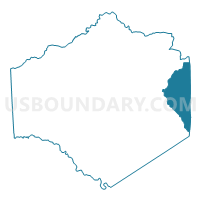
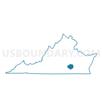
Reams Voting District, Dinwiddie County, Virginia
About
Outline

Summary
| Unique Area Identifier | 681406 |
| Name | Reams Voting District |
| County | Dinwiddie County |
| State | Virginia |
| Area (square miles) | 25.90 |
| Land Area (square miles) | 25.88 |
| Water Area (square miles) | 0.02 |
| % of Land Area | 99.90 |
| % of Water Area | 0.10 |
| Latitude of the Internal Point | 37.09021050 |
| Longtitude of the Internal Point | -77.42416140 |
Maps

Graphs
Select a template below for downloading or customizing gragh for Reams Voting District, Dinwiddie County, Virginia


Neighbors
Neighoring Voting District (by Name) Neighboring Voting District on the Map
- Little Zion Voting District, Dinwiddie County, VA
- New Hope Voting District, Dinwiddie County, VA
- Richard Bland Voting District, Prince George County, VA
- Templeton Voting District, Prince George County, VA
Top 10 Neighboring County Subdivision (by Population) Neighboring County Subdivision on the Map
- Rives district, Prince George County, VA (7,575)
- District 3, Dinwiddie County, VA (5,968)
- District 4, Dinwiddie County, VA (5,211)
- Templeton district, Prince George County, VA (4,623)
Top 10 Neighboring Unified School District (by Population) Neighboring Unified School District on the Map
Top 10 Neighboring State Legislative District Lower Chamber (by Population) Neighboring State Legislative District Lower Chamber on the Map
Top 10 Neighboring State Legislative District Upper Chamber (by Population) Neighboring State Legislative District Upper Chamber on the Map
Top 10 Neighboring 111th Congressional District (by Population) Neighboring 111th Congressional District on the Map
Top 10 Neighboring Census Tract (by Population) Neighboring Census Tract on the Map
- Census Tract 8406, Dinwiddie County, VA (6,839)
- Census Tract 8505.01, Prince George County, VA (5,984)
- Census Tract 8405, Dinwiddie County, VA (3,578)